
The day started with an easy 1.5 mile walk along a mostly flat snowmobile road. As we approached the Callaghan Lake Fork the whitewater was audible through the trees. We checked out this stretch of V+ whitewater, and decided to pass on this section.

After some time spent considering where we would begin our bushwhack, we settled on entering the woods about 100 yards east of the Callaghan Lake Fork and held this proximity for the remainder of the hike. The bushwhack was easy going with Emile leading the way, dragging our boats down the slight decline we took time to pear over the gorge walls when it was convenient. Eventually the stream became easily accessible and we descended to creek level shortly below this point.
Where we put in.

There were a couple hundred yards of boulder gardens and a log portage before we reached the confluence with an unnamed stream (originating near Powder Mountain) that marked the beginning of Callaghan Creek proper, discoloring the clear stream and creating the tan colored water those familiar with Callaghan Creek are accustomed to. This is where we had intended to begin paddling and felt good about flows. From this point there were no mandatory portages.
The first 15 minutes were easy boulder bar floating before the river showed its true character and entered a gorge reminiscent of the ones found on the lower stretch. A couple of smaller rapids led to the first ledge, a five-ish footer with a twisting lead in. We set some lax safety at the hole guarding the pool below and took turns paddling this rapid.

Things picked up below here with a couple of boulder gardens and sliding rapids. Shore scouting was always possible at the water level we were running the creek at (-0.05 new gauge/2.45 old gauge).


The signature rapid of the trip was a short ways into this gorge where the walls rose a little and the river dropped out of sight after some slides. There is a scouting eddy a short ways above the entrance to this rapid, adjacent to a notable mid-stream boulder.

This rapid started off with a 6 foot ledge best run far left to avoid a hole and pocket on the right. Just below is a 20+ foot falls, a slide to vertical on the left and a double drop on the right. We spent some time scouting before deciding the right side looked better with the amount of water in the creek. The hazards were the first part of the double drop had a hole/eddy combo that recycled behind the falls, then another hole/pocket combo below the second ledge that would only be a major hazard at higher flows. We felt confident that we could hit the line and set about running this fun drop one at a time. It is worth noting that a portage appeared possible through a gully on the left.

Things picked up below here with a couple of boulder gardens and sliding rapids. Shore scouting was always possible at the water level we were running the creek at (-0.05 new gauge/2.45 old gauge).
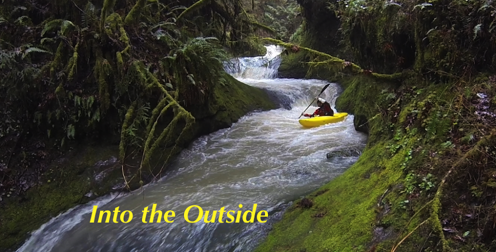
Ben and Emile cruising.


The signature rapid of the trip was a short ways into this gorge where the walls rose a little and the river dropped out of sight after some slides. There is a scouting eddy a short ways above the entrance to this rapid, adjacent to a notable mid-stream boulder.

This rapid started off with a 6 foot ledge best run far left to avoid a hole and pocket on the right. Just below is a 20+ foot falls, a slide to vertical on the left and a double drop on the right. We spent some time scouting before deciding the right side looked better with the amount of water in the creek. The hazards were the first part of the double drop had a hole/eddy combo that recycled behind the falls, then another hole/pocket combo below the second ledge that would only be a major hazard at higher flows. We felt confident that we could hit the line and set about running this fun drop one at a time. It is worth noting that a portage appeared possible through a gully on the left.
Emile drops the double.

Pretty excited about the run so far, we continued downstream. Finding mostly class IV boulder rapids as the gorge continued on, we were a little stressed that we might get gorged in above an unrunnable/unportageable rapid. Before long the walls got more vertical and an ominous drop presented itself as the stream entered a gorge. We went for an extended scout on river right through the Devil’s Club and determined that while the next fifty yards was runnable, it was contained in a vertical walled gorge and the first drop was more dangerous than any of us were comfortable with. Here, Callaghan Creek divided around a midstream boulder and dropped about 6 feet. About 10% of the water went right over a runnable ledge. The rest of the water went left into a siphon that was not conducive to human survival. Just downstream was a boulder that would be a hazard at higher flows, we did not see anywhere to set meaningful safety. Ben and I decided that running the drop was the correct course of action for us, but did not question Emile’s decision to make the exposed and semi-laborious portage on the right.

We did not get any pictures of the siphon from upstream. Here Emile Elliott looks back upstream at the crux move at the head of the gorge.

Both Ben and I made the easy, but necessary move to the right. Emile had a couple sketchy moments on the portage. The three of us felt a weight lift when we had all reached the eddy below this rapid. Immediately downstream the gorge took a sharp right turn and we ducked a log that would require a portage at higher flows (I think you might be able to get out between the two drops if necessary and portage).

The gorge walls recede immediately below the log duck, where a boulder rapid that we ran center to left was next. Then as I recall the remainder of the run was class III-IV read and run with a short and splashy mini gorge thrown in to mix things up. I took out on the left side of the bridge to do shuttle while Ben and Emile continued through the regular Callaghan run.

The gorge walls recede immediately below the log duck, where a boulder rapid that we ran center to left was next. Then as I recall the remainder of the run was class III-IV read and run with a short and splashy mini gorge thrown in to mix things up. I took out on the left side of the bridge to do shuttle while Ben and Emile continued through the regular Callaghan run.
----------------------------------------
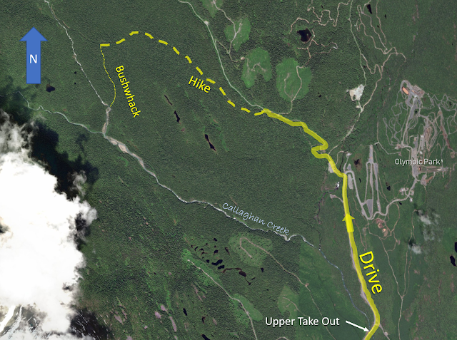
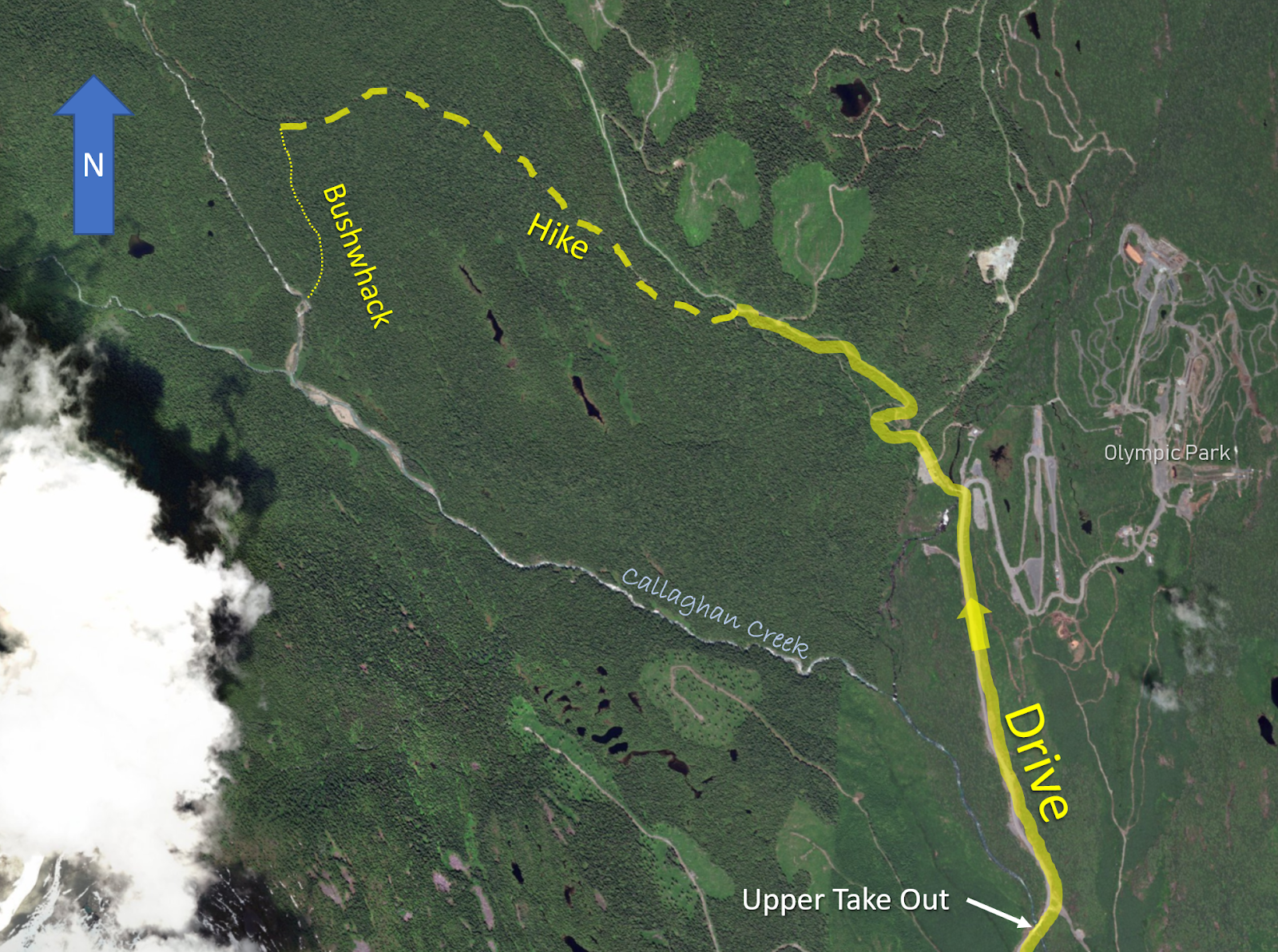
Access: Most who would do this stretch would use it as an extension to the regular section, those paddlers can take out in the Cal-Cheak campground just south of the Hwy 99 (Sea to Sky Hwy) bridge over Callaghan Creek. To only run the upper section, turn off Hwy 99 onto Callaghan Road toward the Olympic Park. In 4.7 miles (7.6 km) a bridge over the Callaghan is crossed. This is the take out if you are not continuing through the lower stretch.
* Between the upper take out and lower put in is a ledge, class II/III bouldery rapids and some gravel bar doldrums.*
Put In: Continue up the Callaghan Road from the upper take out bridge towards Callaghan Lake, 1.4 miles (2.2 km) later (within the Olympic ski area), turn left onto the gravel road towards Callaghan Lake. 1 mile (1.6 km) past the Olympic Park a spur road will branch off to the right (stay on the main gravel road), a very short ways further the road makes a left bend, then a right. Find a pull-out ASAP to park.
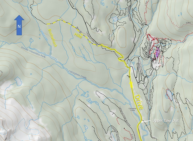
Bushwhack downhill a hundred feet (30 meters) to a snowmobile road, turn right and hike 1.7 miles (2.7 km) to a point where you can hear the Callaghan Lake Fork. Once you have confirmed where you are, enter the woods 100-200 yards/meters east of the Callaghan Lake Fork via a small rivulet. Stay parallel to the Callaghan Lake Fork at this proximity for a little more than a half mile (1 km) to a point where it is easiest to drop into the Callaghan Lake Fork and paddle down to the confluence of the Callaghan Lake Fork and Powder Mountain Fork. This confluence marks the beginning of Callaghan Creek Proper. Be conscientious of wood above the confluence.
Click image to increase size.
click on image to enlarge

Bushwhack downhill a hundred feet (30 meters) to a snowmobile road, turn right and hike 1.7 miles (2.7 km) to a point where you can hear the Callaghan Lake Fork. Once you have confirmed where you are, enter the woods 100-200 yards/meters east of the Callaghan Lake Fork via a small rivulet. Stay parallel to the Callaghan Lake Fork at this proximity for a little more than a half mile (1 km) to a point where it is easiest to drop into the Callaghan Lake Fork and paddle down to the confluence of the Callaghan Lake Fork and Powder Mountain Fork. This confluence marks the beginning of Callaghan Creek Proper. Be conscientious of wood above the confluence.
Click image to increase size.
Water Levels: We had about 2.45 meters on the old Callaghan stick gauge (-0.05 on the new one) and 2.1-2.2 on the Cheakamus gauge. This was enough water for our first trip with plenty of eddies, being from Oregon this felt like a friendly side of medium flow. Knowing that up north they like their rivers full, this would probably be considered low to the locals. A positive, those who paddled both sections of the Callaghan this day felt that the water was better channelized up high.


Callaghan Gauge the day we ran the upper stretch.
It has been run lower.
It has been run lower.


-jacob
No comments:
Post a Comment