All photos by Jarred Jackman

Jarred lives close by and last weekend decided he was ready to see what the run was all about, so he assembled Brandon Lake, John Edwards, Priscilla Macy and myself in Washougal on Sunday Dec 20. We left a vehicle at Dougan Falls in case we decided to continue down through the waterfall section, which looked to be a a friendly flow. We left a second car at the confluence with Stebbins Creek in case time did not allow for further paddling.
The road to the put in got snowy pretty quickly, bottoming out Jarred's CRV. Though Priscilla's Exterra did not have this same problem. We all made it to the put in, but with more snow coming down we were worried about getting the vehicles out at the end of the day. Priscilla decided she was not comfortable dealing with an un/un and committing gorge in the snow so decided to drive one of the vehicles back to the take out. I decided I would drive the other one out and the two of us could go run the NWF Washougal while Brandon, Jarred, and John could collect the beta for the Upper Upper Washougal. With the added comfort of not having to retrieve vehicles at the end of the day.
The shuttle road is blocked 1/4 mile short of river level, next to a compelling, but dangerous falls on Prospector Creek. The walk along the decommissioned road to the put in went quickly and we watched the team paddle off on what looked to be a perfect water level.
The drive out went well and Priscilla and I had a good day on the NWF, but this report is to get the beta out about the Upper Upper. From what I heard from Jarred and John, it is very much worth doing and the un/un is neither un, nor un. They report that while the gorge is committing, scouting options are abound.
I'll turn it over here to Jarred here for an on the water report:
-----------------------------------------------------------------------------
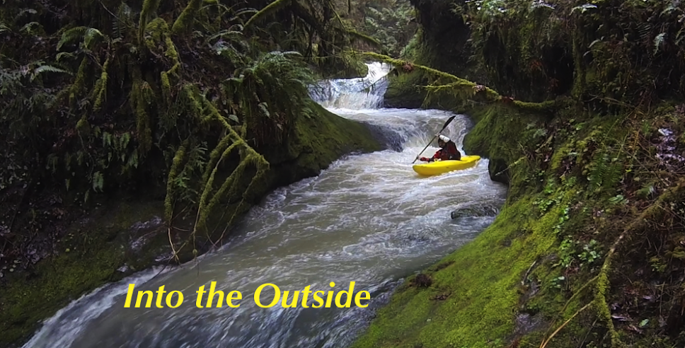
Jarred's Report: The Bennett Guide mentioned a class II warm up but we put on and were immediately met by a III+ ledge that dropped into a narrow landing. Many of the drops on the run had some good lines and some not so good lines. With various rocks still showing and sub-surface boulders it was easy to get bumped offline. This section seemed reminiscent of Trout Creek near the Wind. This isn't a surprise when you look at the map and realize they are VERY close in proximity.

Early On

A couple of these bouldery ledge drops led us to the lip of the first falls (10'+) which is very marginally runnable on the right but the safe line is scraping over the middle into a deep pool. Scout right. The Washougal is plagued by shallow landings and this section is no different, scout carefully.

Typical Rapid on the Upper Upper Washougal

We ran a few more boulder garden style drops and found ourselves at the start of the Gorge. I was expecting an UN UN akin to the gorge on the Carbon. This was nothing like that. I don't think levels would affect this scout or portage.

We scrambled over large boulders and grovelled through devil's club, all on the left bank. Water levels would never negate this option. That said, the portage isn't for the faint of heart and the small spot to gain access to the river could prove difficult to find. We portaged due to difficult WW, tight must make slots, and a bad piece of wood. We put back in after the ledge drop after the Gorge. At portage level you should look for a large fin of rock that seems to block your progress and drop in just upriver of that fin. There should be a ramp that leads down to the river and will offer good seal launch options. We used 15' of rope and the ordeal took us 1.5 hours. If this portage becomes standard, I could see it being similar to Elbow Room on the Ohane (but longer), 30 minutes at most.

Beginning of the Un/Un

We scrambled over large boulders and grovelled through devil's club, all on the left bank. Water levels would never negate this option. That said, the portage isn't for the faint of heart and the small spot to gain access to the river could prove difficult to find. We portaged due to difficult WW, tight must make slots, and a bad piece of wood. We put back in after the ledge drop after the Gorge. At portage level you should look for a large fin of rock that seems to block your progress and drop in just upriver of that fin. There should be a ramp that leads down to the river and will offer good seal launch options. We used 15' of rope and the ordeal took us 1.5 hours. If this portage becomes standard, I could see it being similar to Elbow Room on the Ohane (but longer), 30 minutes at most.
Shot from the fin rock area, indicating where a return to river level is feasible.

From river level, on a return trip
Photo: Adam Edwards

Once back on the water the river turned left and out of sight, we boat scouted as aggressively as was prudent and I think we bank-scouted two drops. One of these ended in a 10' drop in which the right side will mangle you and the left side goes well. Both look good from upstream, so beware. It's easy to eddy hop too far on this run and get into trouble.
The nature of the drops were mostly ledges and boulders with small 2' - 4' drops stacked up. There was a fair bit of mank but normally clean lines could be found without much trouble. The river geology in the harder WW reminded us of the Ohane or UUC. If you know the lines, you're good, if you don't, it could get confusing.

Once we were out of the class IV the river valley opened up a bit, we saw some eagles, stumbled upon some nice surf waves (the Washougal always delivers with surf) and the run returned to the description in the Bennet guide.

We ran a 10-15' drop river left that was near some houses, then we made our way to Doc's Drop.

We scouted and ran this left and it was a classic way to end the trip. It consists of a couple smaller drops and a slide culminating in an upturned lip that launches you (think Boulder Sluice without as much speed.)
Portage options were usually available if a drop was not to ones liking.

Once we were out of the class IV the river valley opened up a bit, we saw some eagles, stumbled upon some nice surf waves (the Washougal always delivers with surf) and the run returned to the description in the Bennet guide.
John getting in some bonus surf action.

We ran a 10-15' drop river left that was near some houses, then we made our way to Doc's Drop.
Clean waterfall near the end of the run.

We scouted and ran this left and it was a classic way to end the trip. It consists of a couple smaller drops and a slide culminating in an upturned lip that launches you (think Boulder Sluice without as much speed.)
So there you have it. No UN-UNs but plenty of challenges and must make moves in a difficult to access river canyon. You'll like this run if it's not at your peak skill level. If it is, well, I hope you don't get injured. Get an early start as you should treat every descent of this canyon as a first. Too many options for changing rapids or dangerous wood.
--------------------------------------------------------------------
Flows: On Dec 15, 2015 Jarred, John and Brandon reported an ideal/medium first time flow with the Washougal reading 1,800 cfs and dropping @ Washougal and 3,500 and dropping @ Hathaway.
Shuttle: The road peaks out just under 2,000'. There was more snow on the north side of the shuttle than locations at the same elevation on the south side, the difference was significant enough I felt it was worth mentioning.
From the Stebbins Creek confluence (conventional take out for this run) continue upriver 4.3 miles (staying right at 1.9 miles) to a point where a number of roads split off from the main one (the 4-way intersection mentioned in the Bennett Book). There are two roads that veer off from the main road to the right at this intersection, you want to take the right turn that goes downhill. After turning right, you will continue downhill 1.5 miles to a bridge over Prospector Creek. Immediately after crossing this creek turn left and continue just shy of 2.5 miles to where this road ends. There is a small pullout adjacent to Prospector Falls less than 50 yards before the road ends that makes a good spot to leave vehicles. From here just continue down the roadbed on foot until it is easy to get down to the Washougal and put in.

No comments:
Post a Comment